While satellite imagery offersextraordinary accuracy of the contemporary topography, the reader should be cautioned that ancient landscape, and especially the coastline might have been considerably different than today. Good examples of this fact are the locations of Troy, Miletos, and Thermopylae. The ancient places existed next to the coast or a largeharborwhile today they appear landlocked. In several such cases, I have drawn the ancient coastline after considerable research, and I hope to add more in the future.
: View the placemarks on terrain generated from satellite photos
The following version is availabe via Google Maps. It contains just about the same data, except the maps above are updated and will continue to be updated.
Send me an emailand help me improve the accuracy of thismap.
Please be aware that this method only allows searches up to the letter S during to some technical issues that should be resolved soon.
Disables the hyperlinks in placemarks
This is a relatively large file so be patient while it downloads.
Approximate Locationmeans that despite all my efforts I was unable to locate the exact ancient place on the map. The placemark is on the most commonly accepted location and should be considered accurate within the vicinity of the pin on the map.
Accurate Placemarks:Ifneither approximate nor general appear in the pop-up window, the placemark indicates the exact location on the map of the ancient Greek place. Most often, the ruins of the place are visible in Satellite view under or near the placemarkafter zooming in. By accurate is meant as accurately as possible. While the placemark is located onthe ancient excavations, the excavated ruinscould be a small part of the actual ancient location that might have relocated several times in the area during the past 4 millennia.
The individual files are large (1300x1200px, ~50-100KB each, JPG)
Did you see an error or an omission? Do you have have more accurate information about a place on the map?
This map takes advantage of Google Maps architecture, and it is growing over time. I put it together for my own research purposes, but soon realized that it could be a useful tool for others.
Click for larger view (1300×1200 ~325KB; JPG).
Click the highlighted place to reveal it on the map
General Locationmeans that the particular ancient Greek place cannot be pinpointed specifically, but instead it spans the general area around the placemark. Mostoften in this case a modern city covers the ancient site.
Thelist on the left of the mapis sorted A-Z. Use the pages at the bottom of the list to find the place you are looking for. Be aware that several places have names that are transliterated in alternative ways. While every effort was made to include as many name variants as possible you might find that some names are missing from the place marks.
Reveals the place names next to the placemarks
You might need to install theGoogle Earth plug-infor this functionality
Earth view allows you to zoom using your mouse controls
In the Find window type the location you are looking for
Go to the top of your screen and select EditFind
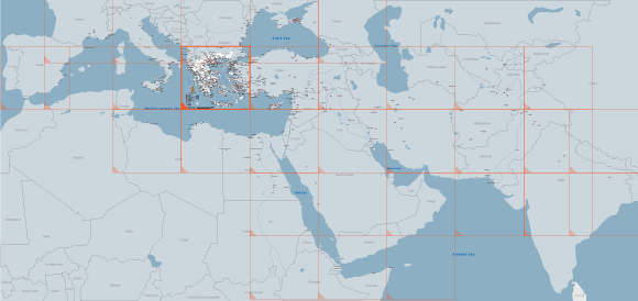
This map is divided into smaller areas to facilitate easier viewing over the internet. Click on each orange square to see each area.
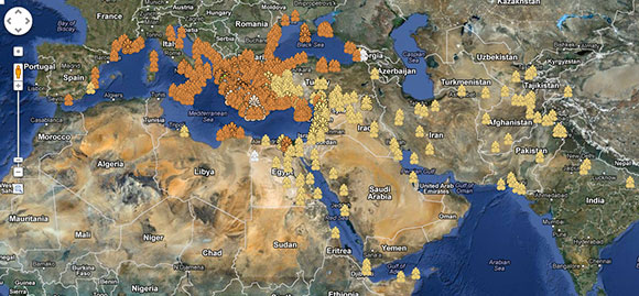
In this map I have identified as many of the major and minor cities, and places of interest of Ancient Greece. To complete the task, I consulted multiple resources, original research papers, old and modern maps, online hints, and ancient texts relevant to each place on the map.
: Allows you to use Google Earth-like interface and buttons.
Offers oblique views of the satellite images
Clicking on each placemark will invoke a pop-up window that contains the name and more information about each ancient Greek place on the map.
Open this mapin a full browser window
The map above displays the ancient Greek cities, places of interest, and centers of influence within and without the borders of the modern country.
*please note that not all sites have been identified in terms of era. This is a long, ongoing process and the map will be updated as time allows.
I have identified each site as either approximate, or accurate. You will find these designations on the pop-up window after clicking on each map place:
The result of the find will be highlighted on the names on the left
Probable Locationmeans thattheexact location of a known place could not be accurately pinpointed on the map. The placemark is placed on the most likely location.